Backend - PAVICS Node
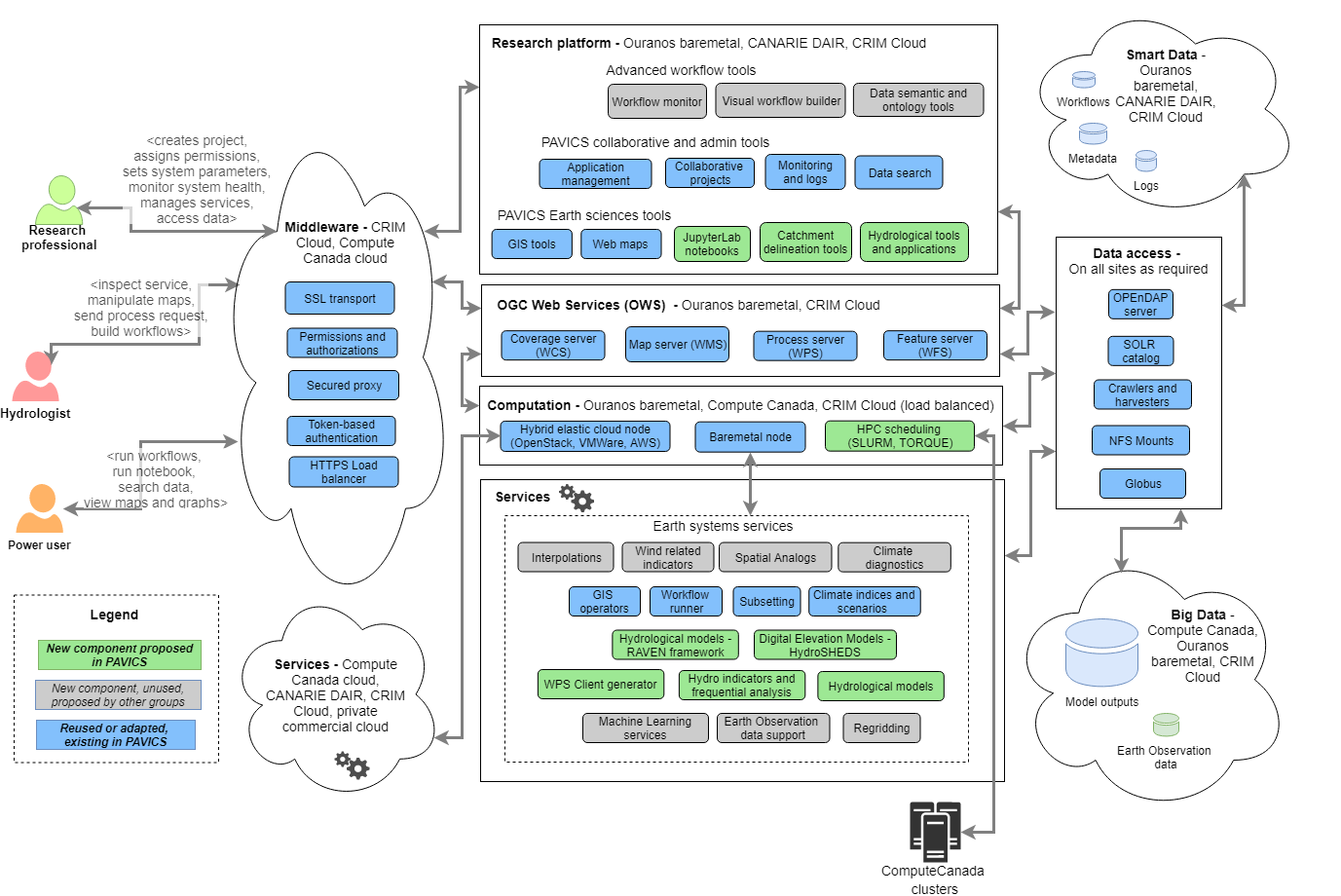
PAVICS nodes are data, compute and index endpoints accessed through the PAVICS platform or external clients. The Node service is the backend that provides data storage, metadata harvesting, indexation and discovery of local and federated data, user authentication and authorization, server registration and management. The node service is therefore composed of several services that are briefly described below, accompanied by links to the full documentation of each individual building block.
The backend of PAVICS-SDI is built entirely with Free and Open Source Software. All of the backend projects (source code and documentation) are open to be inspected, built upon, or contributed to.
Data storage
Data is stored on two different servers: THREDDS for gridded netCDF data, and GeoServer for GIS features (region polygons, river networks).
- THREDDS
- The Thematic Real-time Environmental Distributed Data Services (THREDDS) is a server system for providing scientific data and metadata access through various online protocols. The PAVICS platform relies on THREDDS to provide access to all netCDF data archives, as well as output files created by processes. The code is hosted on this GitHub repository. THREDDS support direct file access as well as the OPeNDAP protocol, which allows the netCDF library to access segments of the hosted data without downloading the entire file. Links to files archived on THREDDS are thus used as inputs to WPS processes. File content cannot however be directly displayed by the frontend and require an intermediary (see ncWMS).
- GeoServer
- GeoServer is an OGC compliant server system built for viewing, editing, and presenting geospatial data. PAVICS uses GeoServer as its database for vector geospatial information, such as administrative regions, watersheds and river networks. The frontend sends requests for layers that can be overlayed on the map canvas. See the GeoServer documentation for more information on its capabilities.
Indexation
Although information about file content is stored in the netCDF metadata fields, accessing and reading those fields one by one takes a considerable amount of time. The strategies used here mimic those used by ESGF, and comprises running a crawler over all netCDF files hosted on THREDDS, extracting relevant metadata and storing them in a SOLR database. Search queries are thus directed at SOLR, which returns a list of links matching the search terms. The crawler is part of the PAVICS-DataCatalog library.
- SOLR
- SOLR is a search platform part of the Apache Lucene project. It is used in this project for its faceted search capability. Search queries are relayed from the UI or WPS processes to the SOLR database, which returns a json file with the links to matching files.
- PAVICS-DataCatalog
- PAVICS-DataCatalog is a database system for storing and serving information about available climate data.
Climate Analytic Processes with Birdhouse
The climate computing aspect of PAVICS is largely built upon the many components developed as part of the Birdhouse Project. The goal of Birdhouse is to develop a collection of easy-to-use Web Processing Service (WPS) servers providing climate analytic algorithms. Birdhouse servers are called ‘birds’, each one offering a set of individual processes:
- Birdhouse/Malleefowl
- Provides processes to access ESGF data nodes and THREDDS catalogs, as well as a workflow engine to string different processes together. Malleefowl Official Documentation
- Birdhouse/Flyingpigeon
- Provides a wide array of climate services including indices computation, spatial analogs, weather analogs, species distribution model, subsetting and averaging, climate fact sheets, etc. FlyingPigeon is the sand box for emerging services, which eventually will make their way to more stable and specialized birds. Flyingpigeon Official Documentation
- Birdhouse/Hummingbird
- Provides access to climate Data Operators (CDO) functions and compliance-checker for netCDF files. Hummingbird Official Documentation
Virtually all individual processes ingest and return netCDF files (or OPeNDAP links), such that one process’ output can be used as the input of another process. This lets scientist create complex workflows. By insisting that process inputs and outputs comply with the CF-Convention, we make sure that data is accompanied by clear and unambiguous metadata.
Authentication and authorization
Access to files and services is controlled by a security proxy called Twitcher, also part of Birdhouse. Upon login, the proxy issues access tokens that allow users to access services behind the proxy. CRIM developed a Twitcher extension called Magpie that provides a higher level of granularity for service access.
- Twitcher
- Proxy service issuing access tokens necessary to run WPS processes or any other OWS service.
- Magpie
- Manages user/group/resource permissions for services behind Twitcher.
Gridded data visualization
The UI can display 2D netCDF fields by making a request to a ncWMS server. The UI will specify which time step of which file to map, and ncWMS will fetch the data from the THREDDS server, then convert the array into an image embedded into a WMS response. This conversion requires a mapping of numerical value to a color scale: a colormap and min/max values. The colormap is defined by the user through the UI, while default min/max values are stored in our SOLR database by the metadata crawler. Users may also specify min/max values directly within the UI.
- ncWMS
- ncWMS is an implementation of the OGC’s Web Mapping Service (WMS) specifically built for multidimensional gridded data such as the netCDF format. The PAVICS platform uses it to convert gridded netCDF data layers from a file or an OPeNDAP link to an image that can be accessed through WMS
GetMaprequests. See this reference paper for more information.